
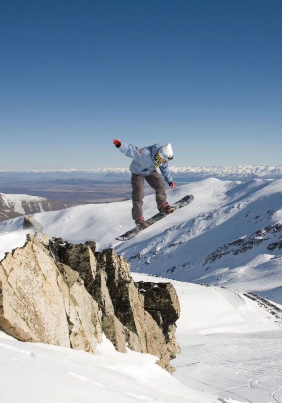
It’s all downhill
There are more than 25 ski fields in this lovely little country of ours, and whether you’re into gently gliding across groomed pistes or consider yourselves the heli-skiing types, we’re here to help you meet your match.
There are more than 25 ski fields in this lovely little country of ours, and whether you’re into gently gliding across groomed pistes or consider yourselves the heli skiing types, we’re here to help you meet your match.
Best for children

Whakapapa: The rising sun strikes early at New Zealand’s largest ski field on the northern side of Mt Ruapehu, softening the slopes, and snow machines ensure a long season here. Whakapapa has thrills and spills for old hands, while Happy Valley is tailor-made for beginners and has its own ski school. You’ll also find all the sustenance and hot chocolate you need at one of the many cafés; Knoll Ridge is the highest in the country.
Skill level: Learner to experienced.
Location: Three hours from Tauranga.
Open: June to October.
Cost: Adults from $73/day.
What’s cool: Happy Valley’s see-through covered lift tunnels.
Best for powder
TūROA: The top of Tūroa is a serious powder playground – even your boss will understand why you need to take a day off to make the first tracks. On the south-western side of Mt Ruapehu, Tūroa has a totally different feel to Whakapapa, with exposed volcanic terrain, wide trails and huge basins. It boasts the longest vertical drop in New Zealand and has the most extensive terrain parks in the North Island.
Skill level: Learner to experienced.
Location: Just under four hours from Tauranga.
Open: June to September.
Cost: Adults from $73/day.
What’s cool: The High Noon Express chairlift that takes you to 2322ft.

Best for going off-piste
CRAIGIEBURN: A club that attracts hardcore skiers and powderhounds, Craigieburn is located in the Southern Alps. Described as ‘cheap, steep and deep’, you won’t find groomed runs here – it’s just one massive off-piste area. If that doesn’t worry you, you’re probably the perfect fit.
Skill level: Intermediate to advanced.
Location: Just under two hours from Christchurch.
Open: July to August.
Cost: Adults $75/day.
What’s cool: A vertical descent that’s been compared to heliskiing – without the helicopter.
CRAIGIEBURN.CO.NZ
Best for all-day sun
MOUNT DOBSON: Usually crowd-free and with great ski schools, Mt Dobson is high up, so the snow is pretty dry, but you’ll also enjoy some lovely sun warming your back. Situated on the main road between Queenstown and Christchurch, it’s close to accommodation and other activities at nearby Tekapo. The chairlift is the centrepiece of the lift system, and there’s a natural halfpipe underneath.
Skill level: Learner to advanced.
Location: Two-and-a-half hours from Christchurch.
Open: July to August.
Cost: Adults from $84/day.
What’s cool: The epic view of Mount Cook.
Best for experts

CORONET PEAK: Coronet Peak is a world-class ski and snowboard spot, featuring state-of-the-art facilities, 280ha of skiable terrain and breath-taking views. It also has the country’s largest fully automated snow-making system, with 217 snow guns, which combined with Mother Nature results in a long season of consistently good skiing and snowboarding.
Skill level: Learner to experienced.
Location: Twenty minutes from Queenstown.
Open: June to September.
Cost: Adults from $119/day.
What’s cool: Night skiing on Wednesdays, Fridays and Saturdays.
Best all-rounder
CARDRONA: Like the sound of New Zealand’s biggest halfpipe? Beginner and intermediate skiers love this easy-going ski field for its wide open spaces – plus it’s often less crowded than some other local spots. With five eateries on the mountain and some of the driest snow around, this ski field really does offer something for everyone – and the drive home over the Crown Range is spectacular too.
Skill level: Learner to intermediate.
Location: Thirty minutes from Wanaka.
Open: June to October.
Cost: Adults from $65/day.
What’s cool: Stopping for a well-earned Speight’s at the Cardrona Hotel.

Path of progress: Motu Trails, Opotiki
How a decade-old cycle trail is delighting both tourists and the local community contributing to its success.

How a decade-old cycle trail is delighting both tourists and the local community contributing to its success.
WORDS Sue Hoffart PHOTOS Jim Robinson, Neil Robert Hutton + Cam Mackenzie
A scenic dunes trail that has resolved a watery paradox for the coastal town of Opōtiki is proving a massive drawcard for both locals and tourists.
Ancient waka travellers and modern-day boat owners have always been able to access the ocean by way of twin rivers that wrap around the Eastern Bay of Plenty township. But it took a cycle trail and handsome suspension bridge spanning Otara River to connect walkers, joggers and bikers with the gloriously long stretch of coastline on their doorstep.
Most of the spectacular Motu Trails cycleway network lies inland, where rugged grade three and four tracks attract hardy mountain bikers keen to test themselves on backcountry roads and steep forest trails. Collectively, they range over 30km of track and more than 150km of gravel and backcountry roads. The most mellow section, though, begins with a pedestrian bridge on the northern edge of town and a delightfully scenic, undulating gravel track running parallel to the shoreline.
Increasing popularity
It is this 9km grade two “dunes trail” that has given the town its beach, according to tourism operator and local resident Volker Grindel. The decade-old trail has become increasingly popular with Opotiki people and visitors.
“Before, everyone needed a car to get to the beach,” Volker says.
These days local children and carless residents can reach the coast safely on foot, by crossing the Pakowhai ki Otutaopuku bridge, rather than having to walk more than 3km along the highway and side road. So too can tourists who arrive by bus or bike. After crossing the river, the trail meanders past grazing Friesian cows and opens onto views of the East Cape and nearby Moutohorā (Whale Island).
“The dunes section is the most used part of the Motu Trails,” Volker says.
“The town kids and people who live here use it a lot for fitness; running, jogging. And the kids who live out of town use it to come to school on their bikes because it’s safer than the highway. I’ve even seen a little fella with training wheels.”

Happy accident
Volker and his wife Andrea operate a small backpackers’ hostel and Andrea runs their busy Kafe Friends coffee cart just off the main street. The German-born couple, who met in Opotiki after her car broke down there, are seeing increasing numbers of day trippers in bike gear from nearby Rotorua, Whakatane and Tauranga.
He says Tirohanga Beach Motor Camp, part way along the dunes, is packed with people using bikes during summer holidays and weekends. Plenty of those campers and cycle tourists make their way along the trail to the town centre.
“Before, they were not taking their kids on that busy road. Now, they come here to town do some shopping, drop in for coffee here or somewhere else. So the Four Square, the New World, the gas stations all get something out of this trail, too.”
Andrea runs along the dunes when she is training for half-marathons, and it is used by dog walkers and local schools that have been inspired to run duathlons and small cycle events for students.
Long-time volunteer trail builder, keen biker and Motu Trails executive officer Jim Robinson does track assessments, as well as overseeing signage, the trails website and Facebook page and multiple other roles. He laughs at his fancy title and stresses the trust-run operation is small and heavily reliant on unpaid community involvement, as well as council and conservation department input. But he says there is no doubting the Motu social and economic benefits, or its standing as a ‘great ride’ of Ngā Haerenga, the New Zealand Cycle Trail.
He is especially enthused by the ongoing planting and beautification programme that has transformed the “really important but environmentally degraded” sand dunes area with the help of about 20,000 flax bushes, cabbage trees, pōhutukawa and other native plants. All have been poked into the ground by volunteers, with another three planting days planned this winter.
Jim says one section of coastline now occupied by the dunes trail had been used for dumping rubbish, other parts had been grazed by stock, or were covered in gorse, kikuyu, boxthorn, pampas and other undesirable invaders.
Points of interest
Interpretive signs denote culturally significant areas, including historic landing sites and burial grounds, and the track route was chosen to avoid especially sacred or sensitive sites.
Local potters and environmentalists Margaret and Stuart Slade provided handmade ceramic tiles depicting birds, mounted on concrete culverts to create sturdy sculpture. Earlier artworks were provided by schoolchildren who painted wooden cut-outs of birds and animals as a conservation week project.

Small tourism operators have sprung up to offer farmstay accommodation, food or shuttle transport to mountain bikers using the trails that connect Opotiki to Gisborne.
Late last year, long-time kayak tour operator Kenny McCracken began offering guided bike tours along the dunes, incorporating local history and food, with an optional swim along the way.
“There’s a massive amount of community ownership of the trail,” Jim says.

Trekking across Greenland with Hollie Woodhouse
I was three hours into trekking across the Greenland ice cap, and all I wanted to do was quit. I’d spent the past six months imagining myself as a strong warrior gliding over smooth snow under bright blue, never-ending skies, the sun warming my bronzed face. The reality, however, couldn’t have been further from the truth.
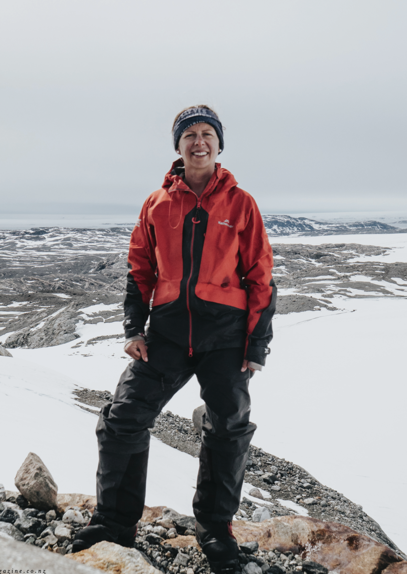
Can you imagine dragging something heavier than you are across a canvas of ice all day, every day for a month? Hollie Woodhouse reckons it’s all about the top two inches.
WORDS JENNY RUDD + HOLLIE WOODHOUSE PHOTOS KEITH PARSONS + BENGT ROTMO
When I first came across Cantabrian Hollie Woodhouse’s magazine Say Yes To Adventure two years ago, I was completely captured by its exciting stories and eye-widening images of people doing things that make you feel like the world is something to climb to the top of so you can truly see how magnificent it is. She published tales of scaling barren mountains in countries I’d never heard of, camping in the ice under the Northern Lights and cycling across continents. At the centre of it all was Hollie herself, a diminutive, blonde handful of sparks. As well as writing about her own adventures, she edited, designed and published the magazine too.
That afternoon, I went for a walk around the Mount and on the spur of the moment, decided to say yes to adventure. I left the track and headed diagonally up, fighting my way through scrabbly scrub and eventually getting stuck. Sweaty and a bit scared, I perched halfway up the slope facing out towards Matakana Island. My only option was to let gravity lead me back to the base track through the dense bush. I arrived home breathless and muddy. ‘Probably won’t mention that to Hollie…’ I thought.
If you ask Hollie about her achievements, she’ll tell you, “I’m not some ultra-athlete, I’m just a girl next door who goes out and gets involved.” But when you consider what she’s done, you realise she’s anything but average. Among other feats, she’s competed in the Coast to Coast, run 250km across the Moroccan desert in the brutal Marathon des Sables, and most recently crossed the 560km Greenland ice cap pulling a sled heavier than she is.
I was expecting her to be a no-nonsense, laser-focused high achiever; instead, when we eventually meet I find a funny, self-deprecating woman with a flair for graphic design. Originally from Ashburton, she’s been spending more time in different parts of the country through being invited to speak at events and share her experiences. Talking to her in Cambridge, I ask what she learned from her Greenland crossing.
“I learned what it feels like to really, really struggle,” she says. “I used to be pretty dismissive of people when they said they couldn’t do something, especially physical things like running 5km or swimming in the ocean, but now I know, because that was me at times in Greenland. I felt like I just couldn’t do it, but our team encouraged me and spurred me on. So I suppose you could say it made me a nicer person!”
I asked Hollie to tell us more about her extraordinary Nordic feat. Here, in her own words, is her story.
I was three hours into trekking across the Greenland ice cap, and all I wanted to do was quit. I’d spent the past six months imagining myself as a strong warrior gliding over smooth snow under bright blue, never-ending skies, the sun warming my bronzed face. The reality, however, couldn’t have been further from the truth.
My 55kg were struggling to pull the 60kg pulk (sled). My skis had a mind of their own, sliding uncontrollably from underneath me, too often seeing me face plant into the icy snow. It’s funny how dreams never quite work out that way we intend, but to hell with happy endings. Ultimately, I was there for the story.
I was part of a six-man team (Antarctic Heritage Trust executive director Nigel Watson, polar guide Bengt Rotmo, and four explorers: New Zealanders me and Brando Yelavich, and Australians Bridget Kruger and Keith Parsons) led by the Antarctic Heritage Trust for its third Inspiring Explorers’ Expedition – a 560km trek across the Greenland ice cap. The trust’s mission is to conserve, share and encourage the spirit of exploration, something they believe is critical in the 21st century. This expedition was to do just that while honouring the remarkable legacy of Fridtjof Nansen, who made the first crossing 130 years earlier.
“I learned what it feels like to really, really struggle.”
Growing up on a sheep and beef farm prepared me for the rough and tumble of the outdoors, but nothing could have prepared me for this adventure. Even though expeditions in freezing climates had never been on my bucket list, however, I knew this was a once-in-a-lifetime opportunity, not to be missed.
Best described as being trapped inside a ping-pong ball, Greenland was far removed from my everyday reality. Life was broken down into the most basics tasks. It would take me 15 minutes every morning to squeeze my feet into my frozen boots while balancing awkwardly in our two-man tent. After boiling water, eating breakfast, then clumsily taking down our tent (a small feat in itself when wearing three layers of oversized mittens) we’d line up ready to tackle the next 20-odd kilometres of the day.
Using the sun and wind to navigate, we’d ski in a line, one behind the other, with a 10-minute break every hour. After anywhere between 10 and 16 hours of skiing, time would be called and the evening routine would commence. Tent up, water boiled, dinner eaten, team meeting, diary entry and finally, sleep. Wake up, repeat. I now understand the meaning of the term ‘Groundhog Day’.
We battled unseasonable wild weather, including two hurricanes. Each time, we dug down our tents to escape the full force of the ferocious winds. Using the excess snow, we built giant walls, their proximity to the tents critical, down to the last centimetre. We hunkered down for up to 30 hours at a time, snow falling like cement around us. These delightful moments were considered ‘rest days’; there’s nothing like the steady drum of 180km/h wind to lull you to sleep.
As the days turned into weeks, my body slowly became accustomed to the new normal. With every step, I managed to grasp the skill of Nordic skiing. Instead of fighting the unnatural movement, I was able to switch to autopilot and would often find myself in a state of flow. It was during these moments that I was reminded why I say “Yes” to the unknown.
“Instead of fighting the unnatural movement, I was able to switch to autopilot and would often find myself in a state of flow.”
We were told the trip would take us anywhere between 22 and 25 days, so we took 27 days worth of food, just in case. Our fuel was high-energy, high-fat foods including nuts, chocolate, chips and lollies – a five-year-old’s dream. On the morning we were due to leave, Bengt was concerned we didn’t have enough to eat. A small detour on our way to the ice cap took us to a tiny supermarket where we bought more food, including three blocks of Norwegian butter. At the time, I questioned if I’d ever be in a situation where I’d voluntarily eat three blocks, but towards the very end of our trip, as I sliced off chunks and ate them straight, I cursed myself for not buying more.

Towards the end of our journey, we were up against it. Storms and sickness had slowed us down considerably, and with five days left and more than 170km still to cover, tensions were high among the team. Would we make it? More importantly, did we want to make it? Frustrations aside, we decided not to call the helicopter, instead opting for human power to get us to the finish – or at least as far as possible.
Pushing on, the final day provided the best conditions of the entire crossing. With our boat having literally sailed, a helicopter was organised to pick us up, regardless of our location. After battling whiteouts, powder up to our knees, relentless winds and temperatures as low as -39.5°C, we could finally smell the salty sea air.
After 22 non-stop hours, I ungracefully pizza-wedged to a stop for the final time. With tears sliding down my sunburnt cheeks, I was overwhelmed with emotion: elation, pride and an immense sense of achievement (and relief in knowing I never had to pull on my boots again!). In a season in which only a handful of teams successfully made it across the ice, I couldn’t have been prouder.
As I peered out the window, safe in the helicopter that was transporting us back to a warm shower and a decent meal, I watched the vast white of the ice cap below. From east to west, 29 days later (five days more than expected), Greenland had brought me many lessons, complete hopelessness, uncontrollable laughter and life-long friendships.
Eight years ago, I made a pact with myself to do one big adventure each year that challenged me, like New Zealand’s Coast to Coast, and ultra-marathons across Morocco’s Sahara Desert and through Peru’s Amazon jungle. While these experiences left me wanting more, Greenland changed me. I came home with a huge appreciation for my life – my boyfriend, my family and friends, my job and just how lucky I am to live in this incredible country.
This adventure taught me the true definition of resilience, and that ultimately, it’s all about the top two inches. I go on adventures to push myself, and to experience moments I never thought possible. Greenland dishedthese up in bucketloads.
In Nansen’s Footsteps, a documentary about this epic expedition, can be viewed at inspiringexplorers.com.
HOLLIEWOODHOUSE.COM
